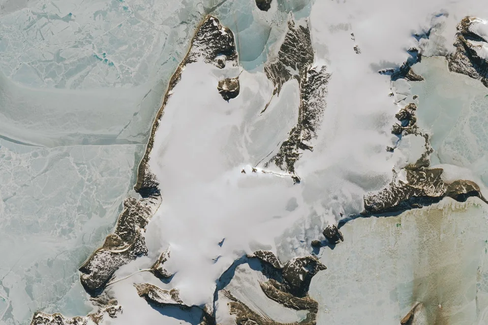
- NASA Earth Observatory published its comparison of Vega Island on 30 October.
- Landsat 9 acquired the images on 22 March 2025 and 10 October 2026.
- The island’s apparent mouth is a lateral moraine, and the jaw is Bahía del Diablo Glacier.
Inside this story 2 perspectives
The apparent eye socket in a satellite picture of Vega Island is a rock outcrop sticking up through Antarctic ice. A ridge of debris supplies a mouth, and a glacier gives the face a lower jaw. NASA Earth Observatory published the comparison on 30 October. Once the shape has been spotted, it is rather hard to look past it. Yet the differences between the pictures tell a more interesting story than their resemblance to a skull.
The Operational Land Imager on Landsat 9 recorded the two views on 22 March 2025 and 10 October 2026. Vega lies east of the Antarctic Peninsula in the Weddell Sea. March is early autumn there, October the southern spring. NASA explains that cloud obscured the island in March 2026. The dates are observations the satellite could obtain, rather than a neatly matched year-to-year comparison.
What the lighter surface conceals
In the March picture a coating of snow makes the glacier look comparatively bright. In October, much more of the darker ice underneath is visible. Glaciologist Mauri Pelto told NASA that above-average winter temperatures played a part. Limited accumulation of new snow, snow lost directly to the air and the scouring effect of wind all contribute to what appears in the image.
The change in colour matters to the glacier. Bare ice absorbs more incoming solar energy than a brighter cover of snow. As daylight lengthens into the southern summer, that difference can affect melting. A fresh fall of snow could alter conditions again. The October image captures a surface that may influence what happens next, without establishing how the rest of the season will turn out.
Which parts of the face keep a history?
The outcrop forming the eye is a nunatak, a rock summit projecting above surrounding ice. The mouth is a lateral moraine, material accumulated along a glacier’s side. The apparent jaw is Bahía del Diablo, or Devil’s Bay, Glacier. These features occupy different positions in the landscape and change on different timescales. A darker surface in one photograph need not mean that a rocky ridge itself has moved.
Researchers have a longer record against which to set the images. An inventory published in 1982 used satellite observations, aerial photographs and maps to identify 29 glaciers on Vega. Devil’s Bay Glacier has been monitored since the southern summer of 1998–99, and NASA notes an overall decline in its mass. More recent regional research has also examined glacier change across the James Ross Archipelago.
Seeing a face is an effective way to find the same features twice. Measuring what has happened to the ice requires the dates, the season, the conditions on the surface and repeated observations. Those details turn a memorable October picture into evidence a glaciologist can actually use.